
A slow guide to Shetland
Laurie Goodlad’s ten-day slow itinerary around Shetland, from Jarlshof to the summit of Ronas Hill.
Words by Laurie Goodlad
Many of us are thinking about how we travel and, more importantly, how we do this in a more sustainable way. For many of us, jetting off on multiple-hop flights just doesn’t sound like a good fit, and we are thinking of ways to travel more slowly, taking a leisurely pace and really savouring the places we visit, spending more time in one destination.
This guide is for anyone who wants to slow down as they travel, adventure more and get off the beaten track. It’s for those who are never happier than when they have mud on their boots, the wind in their hair and a salty sting on their lips as they get under the skin and discover beyond the guide book.
This 10-day itinerary will take you on an adventure of discovery across Shetland, to the four corners and beyond as we explore islands, beaches, hills and the rich archaeology of this small island archipelago that sits on the crossroads of where the North Sea meets the North Atlantic. It is a fairly active itinerary and there is a lot of walking, picnics and secluded havens to explore.
Shetland; where the North Sea meets the North Atlantic
Shetland is an archipelago made up of just over 100 islands. It sits proudly at the edge of the North Atlantic and is made up of 567 square miles of rich moorland, salt-kissed meadows and rugged coastlines. Flanked by the North Sea to the east and the North Atlantic on its western seaboard, Shetland’s position has long made it an important trading point which has helped to sculpt and carve a unique history and culture in both its past and present.
The combination of geographical location, geology and climate give rise to an incredibly distinct, diverse and unique natural landscape. Shetland lies at 60° North; where Scotland meets Scandinavia. The latitude line passes through the sweeping South Mainland, metaphorically slicing Shetland in two. Being so far north means that the days of summer are very long and light, and those of winter are short and dark. In summer, Shetland enjoys up to 19 hours of daylight but, in winter can expect to see only six hours of light. Put simply; Shetland is closer to the Arctic Circle than it is to London.
This slow travel guide will provide a gateway into Shetland’s rich landscape and a unique window into the past. Even if you can’t visit, this guide will provide you with a flavour of these fascinating isles.
Day one
Jarlshof Prehistoric & Norse Site, St Ninian’s Isle & the Crofthouse Museum
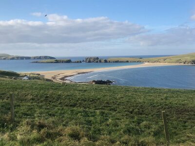
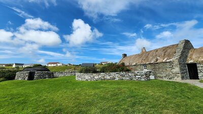
Starting at the southernmost tip of Shetland, a slow and easy transition into the landscape and history is guaranteed by exploring the sweeping South Mainland. Characterised by wide sandy bays, this peninsula runs 25-miles south from Lerwick through stunning landscapes and scenery, and the best concentration of archaeological sites for visitors to see and explore.
Jarlshof makes it onto this list because as far as archaeological sites go – and Shetland has them in abundance – this one literally has it all. It has an – almost – uninterrupted chronology spanning 5,000 years of human history in Shetland.
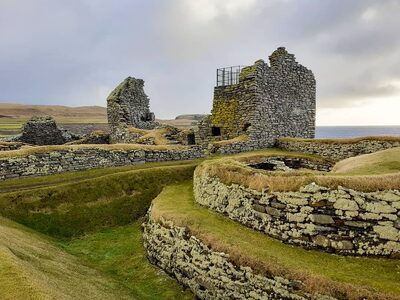
The site, maintained by Historic Environment Scotland, takes visitors on a tantalising journey from the Neolithic (New Stone Age), through the Bronze Age and on into the early, mid and late-Iron Age. The journey then dramatically changes with the arrival of the Vikings and a period of Norse settlement where society, at this time, changed beyond anything that had gone before. From there, visitors arrive into the Early Modern Period and, following the annexation to Scotland in 1469, the arrival of Scottish landowners as Shetland transitions away from Norse rule.
Jarlshof is the largest multi-period site in Europe, and your journey will take you through Shetland’s entire ‘human’ story.
The site is open all year round, although the Visitor Centre is only open May to September.
From here head north, stopping for a visit at the Crofthouse Museum in Boddam, where a traditional, thatched crofthouse welcomes visitors with an open peat fire and a taste of what life would have looked like at the end of the 19th century.
Finally, to while away the afternoon, walk out to the picture-postcard-perfect St Ninian’s Isle.
St Ninian’s is the image that adorns most of the glossy mags advertising Shetland and, the vast sand tombolo, linking the island (St Ninian’s) to the mainland is an impressive sight at over 50-metres long. Take a walk, paddle in the sea, pick up a stone or shell, search for sea glass and listen as the water laps onto the sand at either side. In the summer, this is an excellent place to watch Arctic terns and skuas.
Walk the perimeter of the island, marvel in the geology and abundant wildlife as well as the spectacular views across the North Atlantic towards Foula, Shetland’s most westerly island.
Be sure to visit the 12th-century chapel site, also on the island, where a hoard of 9th-century Pictish treasure was discovered. The chapel was excavated in the 1950s and became the site of a remarkable discovery. Schoolboy Douglas Coutts, helping archaeologists on the first day of the summer holidays uncovered a cross-incised sandstone slab which, underneath, contained a box filled with 28-pieces of highly decorated silverware and the jawbone of a porpoise. Nobody knows why this treasure was buried and why it was never recovered; perhaps we never will, but it is well worth the walk.
Day two
Brochs and castles: Mousa, Scalloway & Clickimin
Staying in the Central and South Mainland, this adventure requires a little pre-planning and a good weather window (to ensure the ferry to Mousa will operate).
Start the day slowly with a walk around the ruins of the Clickimin Broch in the main town of Lerwick. You will be transported back 2,000 years to the mysterious broch era in Shetland where the Vikings were, as yet, an unknown force.
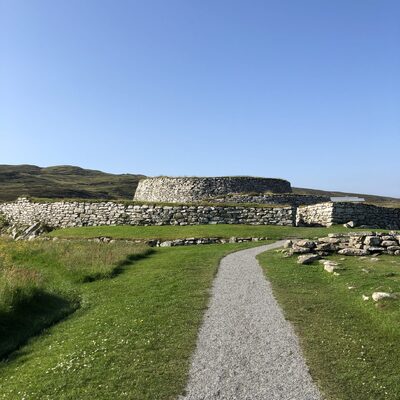
This will be the first of two brochs you will visit today. But what is a broch? A broch, in simple terms, is a 2,000-year-old round tower, unique to the north and west of Scotland. Archaeologists are still not agreed about their purpose. Were they defensive structures? Agricultural grain stores? Homes for high-status members of the community or bolt-holes in times of strife or trouble? Perhaps we will never know…
What we do know is that they have a unique construction; built with a double-wall (an inner and outer wall) with a staircase between the two, leading to the top. Brochs, even today, ask more questions than they answer.
Whatever its original purpose, Clickimin Broch is an iconic building that sits right in the middle of Lerwick and has fascinated islanders and visitors alike for hundreds of years.
From here you will make your way south to the departure point of the Mousa ferry at Sandsayre, near Sandwick where, after a 15-minute boat crossing, you will arrive on the now uninhabited island of Mousa, ready to explore another broch and enjoy a gentle circular walk.
Did you know that Shetland has over 120 broch sites and that Mousa represents the best example of a broch anywhere in the world?
Mousa is now an uninhabited island but, at one time, it supported 11 families, and evidence of the people who lived here is written into the landscape and can be traced in the ruins of houses, mills and stone walls.
On the island, which has no amenities, you will have three hours to hike the perimeter of this RSPB Nature Reserve and have the opportunity to explore inside the broch. Look out for seals, an array of birdlife, and always scan the water for cetaceans that may be nearby.
As well as the scheduled day-trips into the isle, an evening midsummer trip to marvel at the storm petrels (small seabirds who return to nest within the broch walls at dusk) is also an option. These trips are more than memorable; they represent the magnificent culmination of nature played out under the shadow of the 2,000-year-old broch.
Trips into the isle are operated by the Mousa Boat who run a daily service from May to September. Booking for the evening tours is essential.
From Mousa, a trip to Scalloway, Shetland’s former capital, will top-off a fantastic day of history, hiking and wildlife. Dominating the skyline, Scalloway Castle was built by the tyrannical Earl Patrick Stewart and completed around 1600. This was the administrative seat of power in Shetland until the 1830s when Lerwick overtook Scalloway as the main seat of power in the islands.

Patrick was no diplomat, and he was known to quarrel violently with anyone who opposed him – even those closest to him. He was a man with mounting debts who, in response to these, increased taxes on the people. In 1609, unable to ignore the dictatorial nature of Patrick’s rule, and aware that debts were mounting, a party of men were sent north by the King to capture him and bring him back to Edinburgh for trial. Patrick was tried and executed for treason on 6th February 1615.
Throughout the summer, the castle is open every day, and the Scalloway Museum that sits next door is well worth a visit to explore the Shetland Bus history.
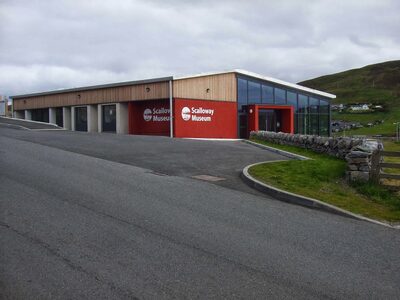
Be sure to walk along the Main Street and explore the village with its small shops and eateries.
Day three
Fethaland, North Mainland
Today’s adventure will take you to the northernmost point of Mainland Shetland (the largest island) to the former fishing station at Fethaland – and you’ll need your walking boots again.
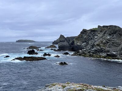
The headland of Fethaland juts proudly into the North Atlantic, and you can view the ruins of about 20 fishing bӧds [booths] where the haaf fishermen would have slept, kept gear and worked with their catch when it was brought ashore during the busy summer fishing season.
Fethaland was an ideal location for the 19th-century haaf [deep-sea] fishing. Using sixerns [six-oared open boats], men would row or sail up to 30 miles offshore to reach the fishing grounds, often on the edge of the Continental Shelf, where they would undertake a dangerous, but prosperous, line-fishery.
This walk follows a farm track for about two miles before walking down the hill towards the shore where you will find the disused fishing bӧds.
Beyond the bӧds, on the headland, sits the small lighthouse and an example of some of the best steatite [soapstone] carvings in Shetland. These carvings in Cleber Geo show the bowl-shaped impressions where Norse settlers carved their bowls from the soft-rock.
From Fethaland, fantastic views across to Unst and Yell to the north and Ronas Hill to the south can be enjoyed.
Day Four
Eshaness and the volcanic North
Today we remain firmly-rooted in the north again, this time the north-west corner of Shetland.
The rugged cliffs at Eshaness are pretty unrivalled in terms of sheer beauty, geology and archaeology. This combination makes for a stunning and spectacular hike. The coastline at Eshaness is said to be the best example of a section through the flank of a volcano in the UK and the lava-formed cliffs are sure to take your breath away.
Park at the lighthouse for the cliffs and coastal walk. The lighthouse was built in 1929 by David and Charles of the famous ‘lighthouse’ Stevensons. The area around Eshaness is geologically fascinating; the peninsula was formed about 360 million years ago when Shetland lay close to the equator, and the cliffs show a series of lava flows dating back millions of years to a landscape of volcanoes, fire and lava.
To the north-west, you see a small island, Muckle Ossa, which is probably the solidified lava vent channel which would have fed the main vent. Walking along Calder’s Geo, which runs parallel to the road and car park, you are tracing the perimeter of an old sea cave that has seen the collapse of the roof, creating a geo (a cleft in a rock). If you continue along the Eshaness Circular walk, you will come to the Hol’s o’ Scraada, a collapsed sea cave 100 metres inland from the sea. Beyond the Hol’s o’ Scraada lies da Grind o’ da Navir; a spectacular natural amphitheatre carved out by the power of the sea, yet formed by lavas and distinctive reddish/pink ignimbrite rock. Walking back, head towards the Hol’s o’ Scraada and trace the burn [stream] up to the Loch of Houlland. You will pass old watermills, similar in style to the Norwegian click-mills, these were used into the early 20th century across Shetland for grinding grain. Beside the loch lies the ruins of the Broch of Houlland, a 2,000-year-old Iron Age round tower which would have once stood proud, commanding the area.
Whilst in the area, be sure to visit the Tangwick Haa Museum and stop for photos at the Dore Holm, the Drongs and take a walk down to the beach at Stenness, another former 19th-century fishing station.
Day five
Unst
In Unst you can tick off all the UK’s ‘most northerly’ destinations; including the most northerly beach, tearoom, shop, bus shelter and the most northerly point.
Shetland has excellent internal links operated by the Shetland Islands Council, including a fleet of inter-island ferries that run between nine of the 16 inhabited islands. Ferries to Yell and Unst are very frequent, and booking is not always necessary, but if travelling with a caravan or motorhome, it is recommended.
In Unst, you get a real sense of Shetland’s geological journey from somewhere south of the equator to its current 60°N position. Take a walk over 500 million-year-old rocks that once formed the ocean floor and look for the famous Edmonston’s Chickweed, endemic to the lunar-style landscape of the Keen of Hamar Nature Reserve.
There is so much to do in Unst; you may want to consider an overnight stay at the Gardiesfauld Youth Hostel so you can see and do as much as possible.
Visit the Unst Heritage Centre and Boat haven to find out about Shetland’s lace knitting and fishing heritage. Explore the Hermaness National Nature Reserve and hike to the cliffs that look out to Muckle Flugga, the most northerly point of the UK. Have lunch and browse the gift shop at Victoria’s Vintage tearooms. Visit the replica Viking longship Skidbladner, and reconstructed Viking longhouse and find out more about Shetland’s Norse roots. And, of course, visit some of the beautiful beaches, including Norwick, the Eastings and Skaw.

And finally, have a photo stop at Bobby’s Bus Shelter. Bobby’s Bus Shelter has become a Shetland treasure, and arguably one of the most visited and photographed attractions on the island. The Bus Shelter sporting a different and imaginative theme every year, was created by local boy Bobby McCauley when he was at school on the island. Bobby, who lived nearby, growing tired of the often long, cold and wet waits in the morning took matters into his own hands and wrote a letter to the local newspaper requesting a new shelter for him to wait in. The shelter was duly built and, soon after, a sofa appeared… and a table… a microwave… and a carpet. Before long, the humble bus shelter was a warm and welcoming place with its very own visitors' book for those seeking refuge and a place to rest.
Day six
Deepdale, West Mainland
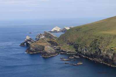
Today we pick up our backpacks and hiking boots and head to the West Mainland where you will find stunning landscapes and generally fewer visitors. Deepdale is located along a remote section of coastline that runs between Sandness to the north and the Dale of Walls to the south. This is the most western extremity of mainland Shetland, where the coastline is most exposed to the unbridled power of the North Atlantic.
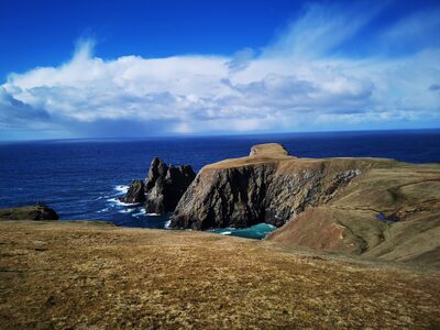
To get to Deepdale: Follow the A971 west towards Walls and then continue towards the Dale of Walls. Park at the Voe of Dale (Dale o’ Waas beach). Remember to pack a picnic lunch and, if you are feeling fit, why not incorporate the Sandness Hill into the walk and really take advantage of the spectacular scenery of the West Mainland.
From almost every point of this 5 mile (8km) walk, Foula, Shetland’s most westerly island, looks impressive on the Atlantic horizon.
As Deepdale comes into view, the gravel beach is imposing and sheer; steep cliffs fall to the sea and onto the gravelly beach below. Extreme care must be taken if attempting to go down to the beach. It is possible, but is not for the faint of heart or those who suffer from vertigo.
This is a challenging climb, and the rocks are crumbly and loose. The walk has some challenging terrain so you must be prepared when setting out.
Day seven
Stanydale & Culswick, West Mainland
Remaining firmly rooted in the West Mainland, today’s walks will take in the core of Neolithic Shetland and another fantastic coastal walk to yet another Iron Age broch.
Start the day at Stanydale and walk the short distance to the Stanydale Temple. Tucked between the hills, this is an excellent place to get-away-from-it-all and enjoy some of Shetland’s rich inland landscapes.
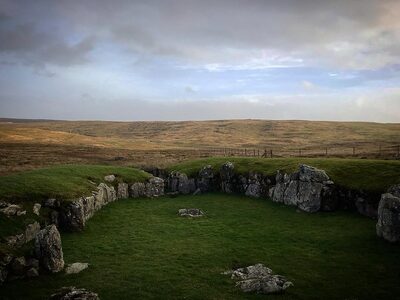
Shrouded in mystery and intrigue, tucked into the empty landscape, archaeologists are still unsure what the purpose of this Neolithic/Bronze Age structure was. The heel-shaped façade is similar to that at Islesburgh (Delting) and Punds Water (Northmavine), but its size is incomparable to anything else locally. This has often been termed a ‘megalithic’ structure and the true function of this 4,000-year-old wonder remains untold. The beauty for any escapist is that its role remains locked only in the imaginations of those who visit.
In the afternoon, and after a pit-stop for lunch at The Original Cake Fridge and Tearoom near Aith, head for Culswick and another hike through the hills and along the coastline. This walk is about 3 miles (5km), and most of it is along a rough farm track.
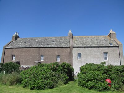
For the walk, park beside the iconic red British phone box, which seems to be in the middle of nowhere, towards the end of the Culswick road. Make your way up the hill to the small Culswick Chapel; this tiny methodist kirk still has services (although not weekly), and the annual carol evening is a firm favourite for people throughout Shetland.
The walk is moderately easy and passes through moorland, skirting the Loch of Sotersta before winding its way up the hill where the broch and the Loch of Brough come into full view. It’s worth taking a little detour down to the abandoned township of Sotersta where the houses now stand roofless and soak up the atmosphere of this once-thriving community.
Despite the track taking you across the moor, the landscape doesn’t disappoint. Look out for the moorland birds, the skylark, lapwing and oystercatcher are all abundant here, as is the curlew, endangered around the UK but thriving here in Shetland. As you get closer to the coast, try to spot the fulmars, shags and other seabirds.
The broch, like many others, has collapsed and been robbed of most of its stone, although the walls can be clearly seen and still stand several metres high in places. The impressive ramparts, internal chambers and a massive triangular lintel stone above the doorway are also still visible. The broch is constructed from red granite, adding a pop of colour to the landscape and an extra wow feature to your photos.
Day eight
Muckle Roe
Another day, another beauty spot. Today, head back towards the North Mainland and onto the island of Muckle Roe, connected by a road bridge to Mainland.
The Hams of Muckle Roe is a circular walk of about 7 miles (11km) and can be quite challenging in places. It’s a good idea to pack a picnic for the day and ensure you are all well prepared.
Muckle Roe takes its name from the Old Norse – literally translating as the Big Red Island. This is because of the fantastic and striking colour of the red granite that makes up the island’s geology and is visible in the spectacular cliff scenery of the area.
From the parking area follow the track between the houses to head down to the Muckle Ayre [big beach], a beautiful secluded red beach. You then follow the path to the lighthouse, which is well signposted.
From the lighthouse follow an OS map (as the track is less defined) northeast along the coast towards the South Ham, passing impressive sea stacks along the way. The whole area is punctuated by incredible caves and stacks, so take your time and enjoy the views as you go.
From the harbour of South Ham walk on towards the impressive natural harbour at the North Ham. From here, make your way towards Town Loch where you can join a farm track that leads back to the main road.
Day nine
Whalsay
Whalsay, whose name means the Whale island, is a small island off Shetland’s east coast and home to Shetland’s large fleet of state-of-the-art pelagic fishing boats. A ferry to Whalsay departs from Laxo and will take half an hour (booking is essential).
Arriving in Whalsay, take a moment to walk around the pier and view the array of fishing boats, large and small at both the pier and modern marina. Fishing is the main industry in Whalsay and, still today, a hugely important part of the island’s economy.
Visit the Hanseatic Bӧd along the shore from the pier where, from the 15th to 17th centuries, German merchants from the Hanseatic League would trade fish with the locals in exchange for seeds, cloth, iron tools, salt, tobacco, spirits, luxury goods and currency. This was a lucrative trade in Shetland and ties with the German Merchants were strong for hundreds of years until a Salt Tax (following the Act of Union of 1707) forbade the import of foreign salt and put-paid to the trade.
Whalsay was also home to Scots communist poet Christopher Grieve (Hugh MacDiarmid). He lived in a house called Sodom, where he produced some of his finest poetry throughout the 1930s. He was called up for war work in 1942 and never returned to Whalsay.
If you are a keen golfer, or just want to enjoy some spectacular views, visit the UK’s most northerly golf course and try a round on the impressive 18-hole course at Skaw.
The Whalsay Heritage Centre is also located in Symbister and has exhibitions throughout the year and is open to visitors.
Day ten
Ronas Hill & da Lang Ayre
Today is a challenging one as we conquer Shetland’s highest point, Ronas Hill in the North Mainland. You can opt to climb the hill, or if you are feeling super adventurous, you can continue towards the beautiful Lang Ayre [long beach] (about 9 miles).
For the walk, park at the top of Collafirth Hill, from here, the summit can be reached within an hour.
Ronas Hill sits in a landscape characterised by the red granite stone intrusion – or batholith – that makes up this fascinating corner of north-west Shetland. Ronas Hill stands proud at 450 metres and often lies cloaked in low cloud and hill fog. Ronas Hill is classified as a Marilyn as it is not high enough to reach Munro status (there are nine Marilyns in Shetland).
Ronas Hill is home to several varieties of Arctic Alpines that have survived here, presumably from before the last Ice Age (which retreated about 10,000 years ago). Of these miniature marvels, there is mountain azalea, alpine lady’s mantle and spiked woodrush. These hardy little miniatures are usually only found on high mountains, or in the Arctic, but they thrive on the tundra-like landscapes surrounding Ronas Hill.
Two features on top of Ronas are notable (other than the alpines); the geocache and the chambered cairn. The chambered cairn is made from weathered granite, and the structure dates to the Neolithic Period – about 5,000 years ago – and contains a large chamber inside. The structure has been added to over the years by climbers who place a rock to mark their achievement of reaching the summit of Shetland.
From the summit, you can head down to sea-level (following an OS map) towards Da Lang Ayre, a mile-long gravel beach of red stone. As you approach the coast, follow the deep ravine that terminates on to the red rocks of the Lang Ayre – this is the only way down on to the beach, and at the top of the cliff, there is a rope to aid your passage. This is a walk that would probably be inadvisable during the winter months.
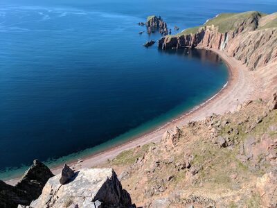
The Lang Ayre itself is a veritable palette of colour; reds, oranges, greys and blues, all thrown together, rocks polished and smoothed in nature’s very own rock-tumbler. Each one placed and formed by the violent North Atlantic that ravages this impressive and imposing coastline.
If you do the Lang Ayre walk, be sure to pack a picnic, hiking boots and download the what3words app before you leave.
---
Laurie Goodlad is a tour guide who runs the business Shetland with Laurie. As a born and bred Shetlander, she is also a writer and podcast presenter who loves to share Shetland’s rich history and culture with the world.
You can follow her blog and podcast at www.shetlandwithlaurie.com or follow on Instagram @shetlandwithlaurie.
Guidance for walkers: Many of the walks featured here explore the open countryside and, although the rules of the Scottish Outdoor Access Code apply, I would ask that you listen to the following podcast for guidance on responsible walking in Shetland.
https://www.shetlandwithlaurie.com/podcast/walking-in-shetland-and-understanding-the-outdoor-access-code
 Out now
Twice a year, to your door
One hundred and sixty pages of Scotland, every photograph commissioned, every word written by someone who went. Members get both issues posted and everything on screen.
 The Last Stop Before Nowhere
 A Weekend Exploring the Isle of Mull
 What's On in Scotland: Autumn and Winter