
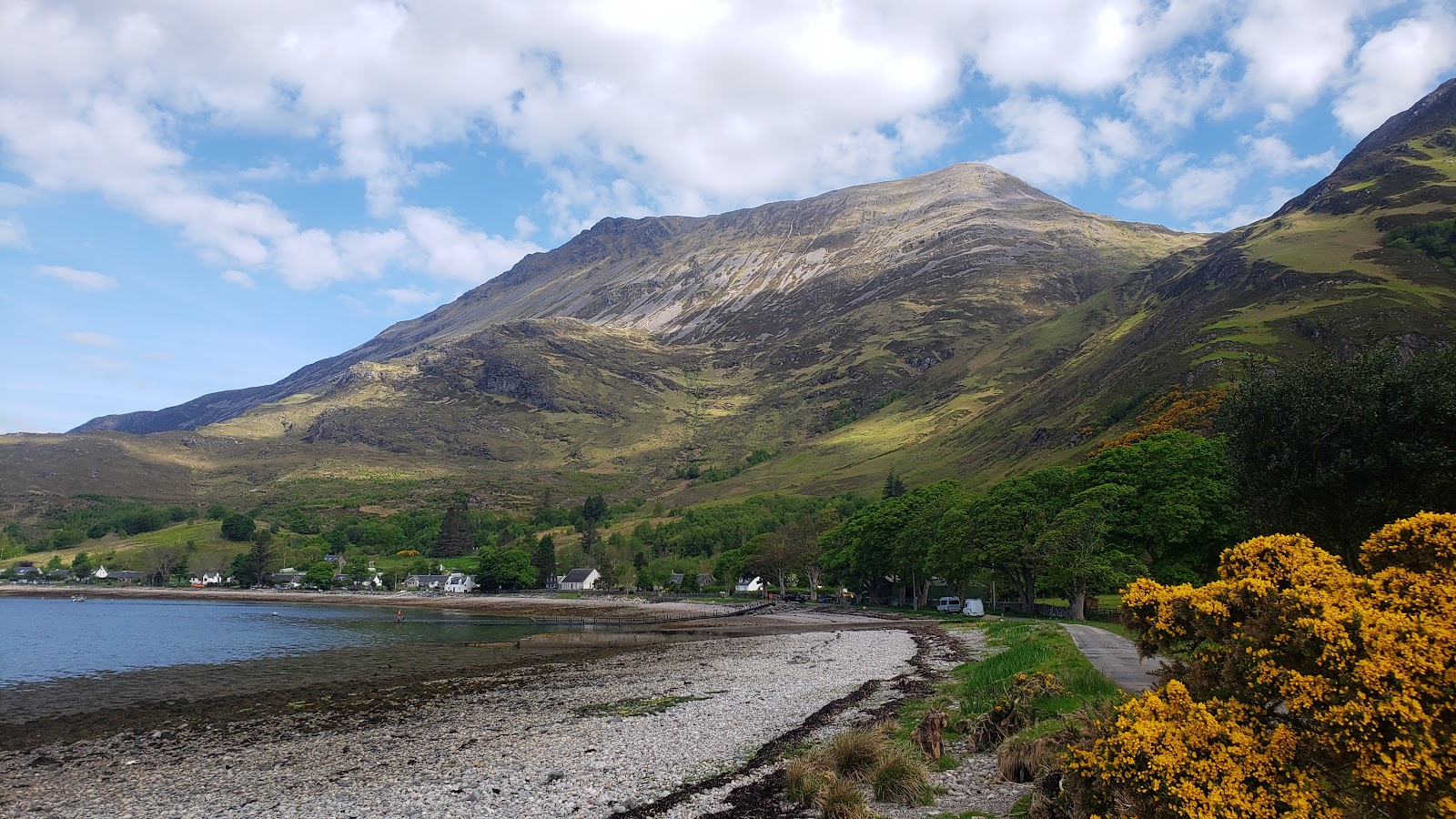
Beinn Sgritheall – Up from Arnisdale by the Bealach Arnasdail
5 miles · 5 to 6 hours · a hill · there and back
Beinn Sgritheall, 974 metres, rises straight out of Loch Hourn above the village of Arnisdale.
The usual way climbs from the road almost at sea level, steeply up a path to the Bealach Arnasdail, then up loose scree to the East Top and west along the ridge to the summit. It comes back the same way. By our map it is about 8 km there and back with about 1,130 metres of climb, and it takes about 5 to 6 hours. It is a short walk but a hard climb, with loose scree and a narrow stretch of ridge: for fit hillwalkers who can find their way with a map and compass.
Where it starts
Start at the roadside parking on the shore side of the road at the start of the hill path, at the west end of Arnisdale: limited, one guide says.
Is it for me?
Tap who is coming, or the day you have, for the answer on this walk.
Before you go
Getting there
There is more at the car park near the end of the public road at Corran, about 1.7 km further east by our map. By the long single-track road from the A87 at Shiel Bridge, over the Mam Ratagan to Glenelg and on to Arnisdale. The Glenelg and Arnisdale Bus Users Group sells vouchers for a taxi from the Citylink coach at Shiel Bridge to Arnisdale, booked at least 24 hours ahead.
On the path
About 5 to 6 hours there and back: about 8 km (5 miles) and 1,130 metres of climb by our map. From the road at the west end of Arnisdale up to the Bealach Arnasdail, the East Top and along the ridge to the summit, 974 metres, and back the same way. A muddy, narrow path climbing steeply from the shore, two fords over the Allt a' Mhuilinn with no bridge, a steep slope of loose scree to the East Top and a ridge that narrows above a big drop. A steep climb of over 1,100 metres from sea level, with loose scree, burns to ford and a narrow stretch of ridge: only for children used to big hill days, with an adult who can navigate. The map to carry is OS Explorer 413, Knoydart, Loch Hourn & Loch Duich (1:25,000); OS Explorer 414, Glen Shiel & Kintail Forest (1:25,000) shows the country round it.
Good to know
Summer and early autumn in daylight, on a clear day with a good forecast and after a dry spell, when the burn is lower and the scree drier. Keep dogs under close control on the hill, where deer graze and stalking may be going on. None at the start of the hill path or on the hill; by our map there are toilets beside the car park at Corran, about 1.7 km further east. No stalking information is given for Beinn Sgritheall in the Heading for the Scottish Hills tables: be prepared to follow reasonable local guidance. Under snow it is a winter mountain with no avalanche forecast.
The walk
The usual way up Beinn Sgritheall starts from the road at the west end of Arnisdale, almost at sea level. A path climbs steeply north above the Allt a' Mhuilinn to the Bealach Arnasdail, then up a steep, stony slope to the East Top, and west along the ridge to the summit. By our map it is about 8 km (5 miles) there and back, with about 1,130 metres of climb. Allow about 5 to 6 hours, more with stops, in poor weather or under snow. No public body publishes a route, a distance or a time for it. Some walkers make a round of it, down the west ridge and a steep wood to the road, then about 3 km back along the road. This walk comes back the way it went.
Arnisdale is at the end of a long single-track road. From the A87 at Shiel Bridge it climbs over the Mam Ratagan to Glenelg and runs on by the coast to Arnisdale. On the pass the bends sharpen and the gradient steepens, the Glenelg ferry warns: a serious challenge for heavy vehicles. One guide gives limited parking on the shore side of the road at the start of the hill path, and more at a car park near the end of the public road. By our map that car park is at Corran, about 1.7 km further east along the road, with toilets beside it. There are none at the start.
Before you set off, check the mountain forecast: the Mountain Weather Information Service's Northwest Highlands forecast covers the hills north from Knoydart. Glenelg Mountain Rescue, whose area takes in Arnisdale, asks walkers to carry an OS map and compass, know how to use them, and use a GPS only as a back-up. Do not rely on a mobile phone, the team warns: in many parts of the Glenelg area reception is poor or there is none. Leave a route card where you are staying or in the car, and give yourself ample time to get back before dark.
The path leaves the road at the west end of the village by a sign for the hill path, and crosses a small burn on a footbridge. It climbs between the houses and the burn through woodland, over grass and damp ground, crossing small streams at fords. Then it turns and climbs steeply beside a line of old fence posts, above the gorge of the Allt a' Mhuilinn. The path is muddy and narrow in places, rough but clear to follow.
About 700 metres out, by our map, the path crosses the Allt a' Mhuilinn, and about 1.7 km out, some 440 metres up, it crosses back. Both are fords with no bridge. After heavy rain the burn runs high: if it is too high to cross safely, turn back. One walker fell into an eroded channel on the way up to the bealach, so watch your feet.
At about 500 metres up the path splits, one guide says. The left fork heads straight up to the foot of the screes below the East Top. The right fork, a little longer, goes on to the Bealach Arnasdail and avoids most of them, and this walk takes it. The bealach is the col between Beinn Sgritheall and Beinn na h-Eaglaise, about 2.1 km out and about 580 metres up by our map.
From the bealach the path follows fence posts across the col, then twists and turns up the steep slope to the west. This is the hardest part of the climb. Walkers call it a very steep scree slope, with loose stones that slide underfoot, and by our map the steepest 100 metres of the walk is just below the East Top. Go slowly and keep your footing. The cairn on the East Top stands at 906 metres.
From the East Top the way goes west along the ridge. It drops about 70 metres by our map to a wide bealach, over a patch of loose, rough ground, then climbs a broad grassy slope. Higher up the ridge narrows for a short way above a significant drop, one guide warns, before grass returns for the last climb to the summit. On the north side the ridge falls away into Coire Mhin; on the south the hill drops almost 1,000 metres to Loch Hourn.
The summit, 974 metres, is a broken trig point among boulders, with Knoydart across Loch Hourn to the south. Beinn Sgritheall means the scree mountain, and the name fits.
On the summit, take a bearing for the way back before you leave. By our map the ridge path leaves the top heading east-south-east, then east to the East Top. A worn path also runs down the west ridge, away from Arnisdale, and one party coming down it missed their turn and had to retrace their steps. If the cloud comes down, the wind rises or anyone is tiring, turn back by the way you came.
Under snow Beinn Sgritheall is a winter mountain, with steep slopes above Arnisdale and a narrow ridge. There is no avalanche forecast for this hill, but that does not mean there is no risk under snow. The Scottish Avalanche Information Service's full winter forecasts for its six areas begin on 17 December 2026. Glenelg Mountain Rescue asks walkers to have the clothing, food and equipment the route and the weather need, and points them to winter skills and avalanche awareness courses.
The Heading for the Scottish Hills tables list Beinn Sgritheall with no stalking information given. They ask walkers to be prepared to follow reasonable local guidance. One walker in late October found stalking going on nearby.
The way down is the way you came, and on the steep slopes it is slow. Leave the summit east-south-east along the ridge to the East Top, then take the path down the steep, stony slope to the Bealach Arnasdail. Follow it down above the Allt a' Mhuilinn, over the two fords, to the road. The descent is hard on the knees, one walker found. In an emergency call 999 or 112 and ask for Police and Mountain Rescue, Mountaineering Scotland says. Give a six-figure grid reference and a named feature if you can. To be able to text 999 where a call will not connect, register first by texting the word register to 999.
If it rains
None on this walk: in rain, low cloud or a high wind, leave the summit for another day. After heavy rain the Allt a' Mhuilinn runs high at its two fords, and wet scree and roots are slippery. In mist take a bearing off the summit, and turn back by the way you came.
Places to stay near the walk
The places to stay nearest the walk.
None of ours is within an hour by road. The nearest, as the crow flies, is Eilean Sionnach Lighthouse Cottage in Isleornsay, 8 miles away.
Then Kinloch Lodge in Sleat, 9 miles away.
More walks near here
Within a short drive of the start.
Did this walk?
Tell the next person how it went. The best go on this page, with your name.
For further reading, before you go.
- Beinn Sgritheall, the Munro page, Hidden Scotland↗
- Advice for walkers, Glenelg Mountain Rescueglenelgmountainrescue.org.uk↗
- Northwest Highlands forecast, Mountain Weather Information Servicemwis.org.uk↗
- Beinn Sgritheall summit forecast, Met Officeweather.metoffice.gov.uk↗
- Stalking tables for the Western Highlands, Heading for the Scottish Hillsoutdooraccess-scotland.scot↗
- The Glenelg and Arnisdale taxi voucher, the Bus Users Groupbug-voucher.co.uk↗
- Calling for help, Mountaineering Scotlandmountaineering.scot↗
Photograph by John Malcolm via Google
Maps from OpenFreeMap © OpenMapTiles, data © OpenStreetMap contributors; heights from Mapzen's terrain tiles.