
Before you go to Isle of HarrisPart 2 of 3
Areas
2 minute read
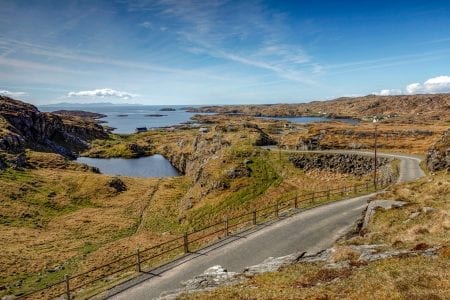
Harris is best understood by exploring its four distinct and dramatic regions.
North Harris This is the island at its most wild and mountainous. Dominated by a range of rugged peaks, including the 799-metre summit of the Clisham, North Harris is a paradise for walkers and those seeking raw, untamed nature. The glens here are home to red deer, while the skies are patrolled by golden eagles. A dedicated North Harris Eagle Observatory offers a chance to spot these magnificent birds.
West Harris The west coast has the beaches. Luskentyre is the most famous, a vast estuary of white sand and blue water with the mountains of North Harris behind it. Seilebost and Scarista have miles of sand for walking. Behind the beaches lies the machair, a unique, fertile grassland that erupts into a carpet of wildflowers in the spring and summer.
The Bays (East Harris) In complete contrast to the west, the east coast of Harris, known as The Bays, is a deeply indented, rocky coastline. The famous "Golden Road" is a winding, single-track route that snakes its way through this landscape of cnoc-and-lochan (little hills and lochs), connecting a string of tiny, traditional crofting townships. It’s a challenging but hugely rewarding drive through a landscape that showcases the resilience of the communities who have made this tough, beautiful terrain their home.
South Harris & The Sound The southern tip of the island is a gentler landscape of rolling hills and sheltered bays. Its main hub is the village of Leverburgh, the ferry port for services to the Uists. The greatest treasure of South Harris is at Rodel: the magnificent 16th-century St. Clement’s Church. This ornate, beautifully preserved church contains one of Scotland's most remarkable medieval tombs and stands as a powerful link to the island's clan history and the days of the Lordship of the Isles.