
Beach bagging in Shetland’s North Mainland
Beaches in Shetland’s North Mainland, from the red shingle of Da Lang Ayre to Stenness.
Words by Laurie Goodlad
A guide to the beaches of Shetland’s rugged North Mainland.
Northmavine is almost – but not quite – a separate island. Formed by fire and ice, its landscape is unforgiving and wild – a far cry from the gently sloping hills of the South Mainland. The harsh landscape is reflected in the dramatic beaches found in Shetland’s north.
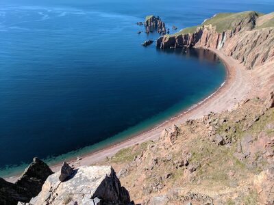
Da Lang Ayre
Translated, da lang ayre means ‘the long beach’, and this is one of Shetland’s longest stretches of beach at one-and-a-half miles. Da Lang Ayre is also one of the most inaccessible beaches in Shetland, but the effort to get there is worth the long and tiring hike beyond Ronas Hill to reach the stunning red shingle expanse. The best way to get to the Lang Ayre is to climb to the top of Shetland’s highest hill (Ronas Hill) and walk on to the ayre, or beach. The walk is about nine miles in length and will take the best part of a day. Ronas Hill is worth a visit. At 450-metres, this is a Marilyn and affords fantastic views across Shetland from the summit. On the way, look out for the several varieties of Arctic Alpines that have survived here, presumably from before the last Ice Age retreated about 10,000 years ago. Of these miniature marvels, there is Mountain azalea, alpine lady’s mantle and spiked woodrush. These hardy little miniatures are usually only found on high mountains or in the Arctic, but they thrive here. Access down to the Lang Ayre is via a rope and involves scrambling down loose rocks and debris. The effort is worth it as the colours of the red granite beach glimmer in the sun, and the steep-sided cliffs rise around you.
Uyea
This is another beach that is not for those who are shy of walking as Uyea is another of Shetland’s inaccessible beaches. As with the Lang Ayre, the efforts will be rewarded at the end of the walk when you reach the tidal island of Uyea, linked by a stunning sand tombolo. Uyea was once a crofting township, and evidence of the people who lived there can still be seen in the croft buildings. Today it is still used during the lambing season.
*Please note that both the Lang Ayre and Uyea are more challenging walks, and hikers should download the What3Words app before they leave and always go prepared, checking a weather forecast before departing.
Hillswick beach (Sandwick)
Hillswick sits like an emerald within the rugged North Mainland. Its lushness is in sharp contrast to the surrounding granite and the harshness of Shetland’s north-west corner. Hillswick’s best beach lies in Sandwick bay, and as the name suggests, it’s a beautiful white sand expanse with impressive views across the bay towards the Heads of Grocken. This is the perfect beach to enjoy a barbecue or picnic and dip your toes in the water.
Heylor
Heylor sits tucked under the shadow of Ronas Hill on the edge of the long finger of Ronas Voe. Heylor is just a few miles from Hillswick. Turn towards Heylor at Urafirth, fork to the left after about a mile and follow the road until you reach ‘The Blade’. Evidence of a fishing past can still be seen here with a disused building and the rusting remains of a pier, now almost entirely engulfed by the beach that has built up over the years by the constant action of the sea. This was once an important herring fishing and whaling area, with the sheltered waters of Ronas Voe providing a natural harbour for boats. From here, you are looking right across to Ronas Hill, a great red granite batholith that stands proud in the landscape. As with everywhere in the north, the colours of the rock will take your breath away no matter what the weather is like.
Stenness
The beach at Stenness, just a mile from Eshaness Lighthouse, is an impressive gravel beach within a sheltered bay. During the 19th century, this was an important fishing station for many of the haaf fishing boats who went many miles out to sea in open boats to fish. There’s a large two-storey building at the head of the beach that now stands in ruin and the foundations of numerous smaller booths used for processing the catch and acting as bunk-rooms for the fishermen during the summer months. The beach is a geologist’s dream, with small crystals known as agates found on the beach. These beautiful red gem-like stones were formed during a volcanic eruption when the area was part of a volcanic chain many million years ago. It may be tempting to take one home if you find it, but as Shetland is a UNESCO Geopark, people are kindly asked to photograph them and leave them on the beach.
 Out now
Twice a year, to your door
One hundred and sixty pages of Scotland, every photograph commissioned, every word written by someone who went. Members get both issues posted and everything on screen.
 The Last Stop Before Nowhere
 A Weekend Exploring the Isle of Mull
 What's On in Scotland: Autumn and Winter