
Hiking in Shetland
Shetland’s best walks, from Ronas Hill to the Hams o’ Roe and Hermaness.
Words by Laurie Goodlad
Walking and hiking are some of the best ways to see Shetland and take in the ever-changing landscape. Shetland’s unique wildlife, dramatic scenery and world-class geology are best explored on foot, especially during the long days of summer.
You can explore gently sweeping sections of sheltered coastline or rugged and exposed headlands battered by the North Atlantic and punctuated by sheer cliffs that drop spectacularly to the sea. Shetland has no Munros, but the highest point, Ronas Hill, dominates the landscape of the North Mainland at 450 metres and is one of 19 Marilyns that rise 150 metres or more from the sea.
Shetland’s countryside is free to explore, and walkers have the right to access most of the outdoor landscape freely. Still, it’s worth checking the Scottish Outdoor Access Code before setting off into the hills to ensure that you roam responsibly.
How to pick a walk?
With over 1,000 miles of coastline and no shortage of inland hikes over open moorland and rugged hills, it can be difficult to select the right walk – particularly if you are time-limited. If you are unsure where to go, it’s worth checking out the network of core paths that are peppered throughout the islands and, more often than not, lead to some of the best scenic spots on the islands. Some of these trails are better marked with waymarkers than others, and, unlike many of the core paths and trails that you find on the Scottish mainland, many of the walks are not clearly marked. It’s definitely worth taking a map and studying it at the start of the trail – many of these routes have a map marking the way displayed at the beginning of the walk, and it’s worth taking a photo of this on your smartphone before heading off on the walk.
There are several walking routes detailed on Shetland.org, where you can search by area, difficulty and time. This means that you can easily find a walk that will suit your time and ability when visiting.
A few of the best
Ronas Hill and the Lang Ayre
This is probably one of Shetland’s most challenging walks, and it involves walking to the highest point at Ronas Hill before heading down the other side to sea level again. Despite this, it is one of the most beautiful walks out there, culminating in the stunning red-gravel Lang Ayre beach – a vast stretch of beach flanked by the high, granite cliffs of Ronas Hill that tower above you from sea level. Access to the beach is via a rope, but the effort is worth it. Ronas Hill itself has a fascinating landscape, with several varieties of Arctic alpines that thrive on the tundra-like hillside, presumably from before the last Ice Age that retreated about 10,000 years ago. Of these miniature marvels, there is Mountain azalea, alpine lady’s mantle and spiked woodrush. These hardy little miniatures are usually found on high mountains or the Arctic, but they thrive on Ronas Hill’s remote and exposed hillsides.
Hams o’ Roe
This walk can be done as a circular or shortened by following the farmer’s track there and back (rather than taking the circular coastal route). Either way, this walk on the island of Muckle Roe – the Big Red Island – offers some of the best scenery in the islands. The coastline here, facing the North Atlantic, is scarred by the sea, and the red granite is cut into cliffs, stacks, caves and arches.
Hermaness
Britain’s most northerly walk takes the hiker through the National Nature Reserve at Hermaness towards impressive colonies of puffins and gannets that noisily nest on the steep cliffs and outlying stacks around Unst’s most northerly peninsula. Before heading back towards the car park, the final destination on this walk overlooks Muckle Flugga Lighthouse, the most northerly lighthouse in the UK. There is something so surreal about sitting on that final headland, with puffins and gannets flying overhead and looking north towards the Arctic.
St Ninian’s Isle island circular
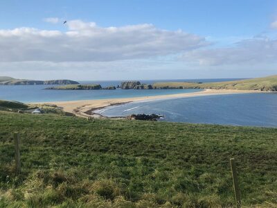
This walk is more gentle and less taxing physically than those listed above. Still, it does offer some beautiful coastal scenery, wildlife, cliffs and geology – as well as a good smattering of archaeology thrown in for good measure. The walk begins at the sandy tombolo of St Ninian’s – an impressive sand bar that links the island of St Ninian’s to the mainland. The tombolo is passable for most of the year, although the sea can wash over it in winter when it’s stormy. The island is known for an impressive treasure hoard discovered here in the 1950s and dating back to the 9th century. In 1958, schoolboy Douglas Coutts discovered the St Ninian’s Isle treasure hoard. He had joined a team from the University of Aberdeen on a dig led by Professor O’Dell at the 12th-century chapel site. It was the first day of the summer holidays and his first day on site. He was sent to a corner of the site, away from the important work of the ‘real archaeologists’. He was handed a trowel and set to work digging. It wasn’t long before he unearthed a cross-marked slab. When the slab was removed, it revealed a larch box, placed upside down. Inside the box, the excited team discovered one of Scotland’s most significant treasure hoards. The treasure comprises twenty-eight pieces of highly decorated silverware (the main items are brooches, bowls and pieces of weapons) and a fragment of a porpoise’s jawbone. It is thought that the treasure is Pictish and dates to about AD 800.
Da Brigs o’ Vementry
All the walks featured here are coastal walks, but you are never more than a few miles from the sea in Shetland. Da Brigs o’ Vementry is a walk that feels more ‘inland’ – despite the fact that it too leads to the sea – as it takes you over open moorland towards a sheltered inland voe, rather than the open ocean of the other walks featured here. This is also an easy walk, and it does have a rough path leading to ‘da Brigs’. Da Brigs is an old stone causeway that crosses the sea halfway between Vementry and Clousta. You may be fooled into thinking that this is a long walk – in fact, driving from Clousta to Vementry would probably take you longer than the walk. Driving between these two points would take you about 15 minutes over eight miles of winding single-track roads, but the hike we did was just over three miles, and we walked beyond da Brigs and over the hill to Clousta. This was the route that school children took to get to school in Clousta from Vementry and the postman also used it to deliver the mail on foot between Vementry and Clousta. Da Brigs is a stone causeway and dry stone wall, with a wooden gate allowing access over the causeway. The stone walls ensure that sheep remain on the right side of the water.
We are guests in nature
Shetland hosts a diversity of flora and fauna. Many of the areas are ecologically sensitive, so, when visiting, it’s important to treat these places with respect so that everyone can enjoy them. Don’t be the person who scares a red-throated diver from her nest or the person responsible for another bird becoming entangled in plastic pollution. Be the responsible hiker who leaves gates as you find them, carries litter home and leaves no trace.
Safe travel
If you are organising one of the longer hikes, remember to prepare wisely. Download the What3Words app, check weather alerts before you leave, and make sure you have plenty of food, water and warm clothing as the weather can change quickly.
Most importantly
Have fun and enjoy getting to know Shetland on foot.
 Out now
Twice a year, to your door
One hundred and sixty pages of Scotland, every photograph commissioned, every word written by someone who went. Members get both issues posted and everything on screen.
 New Town Walking Tour
 The Best Walks in the Cairngorms